World Geography : Climate, Weather & its Classifications, Wind System, Humidity, Precipitation & Distribution of Rainfall. ( UPSC )
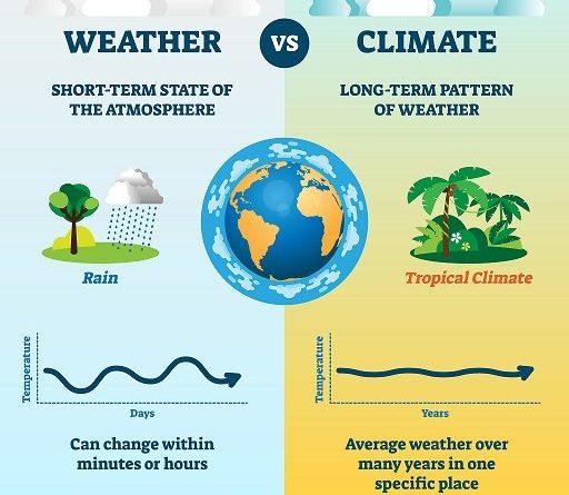
Climate
- According to the International Institute of Meteorology, the average of 31 years of weather’s different elements is called climate.
- In simple words, the long-term average of the day-to-day weather of a place is called its climate.
Weather
- The weather of a place is the short term sum of its atmospheric conditions (temperature, air pressure, wind, humidity, and rain).
- Weather is a transient state of the atmosphere.
Wind System
- Wind refers to the horizontal movement of air which acts parallel to the pressure gradient and perpendicular to the isobars, whereas wind current refers to the vertical uplift of air.
Factors of wind generation
- Pressure gradient force
- Proportional to wind speed and pressure gradient force of 20 C) – 36 km/h
- Coriolis force
- Negligible at the equator, more at the poles.
- Deceptive not real.
- Left and right in the southern hemisphere.
- Decreases with height.
- After 32 km altitude, the effect of Coriolis weakens.
- Friction
- This force reduces the effect of Coriolis and the speed of air.
- Geo-strophic force
- It is a resultant force which is the product of the Earth and Coriolis forces and the frictional forces.
- If the force of friction is less then the Coriolis effect will be more and the wind protection becomes almost parallel to the isobars, which is called deflection.
Humidity
Water vapor present in the air is known as Humidity.
- Absolute Humidity
- The actual amount of the water vapor present in the atmosphere is known as the absolute humidity.
- It is the weight of water vapor per unit volume of air and is expressed in terms of grams per cubic meter.
- Relative Humidity
- The percentage of moisture present in the atmosphere as compared to its full capacity at a given temperature is known as the relative humidity.
- Relative humidity is greater over the oceans and least over the continents (absolute humidity is greater over oceans because of greater availability of water for evaporation).
- The relative humidity determines the amount and rate of evaporation and hence it is an important climatic factor.
- Specific Humidity
- It is expressed as the weight of water vapor per unit weight of air.
Forms of Condensation
- Fog
- Visibility is 1 km. or less than.
- Fog is actually a low level cloud which is formed at 4 am in winter because due to the intense long-wave radiation of the surface, a condition of inversion of temperature is created and condensation takes place on the surface.
- Smog
- Visibility is few meters.
- Occurred in urban landscape because aerosols, pollutants, carbon particles are present in the atmosphere which mixes with fog to form smog fog.
- Mist
- The visibility of the mist is 2-3 km.
- Mist is formed by suspension of tiny or fine water particles in air
- Raindrops before falling on the ground, break into a size of about 10 microns and remain in the suspended state in the air.
- Haze
- Visibility 3-5 kms.
- It forms due to spread of dust particles in the atmosphere or the effect of methane on paddy fields or short-term condensation actions.
- Smaze
- Air pressure
- Like other material substances, air also carries weight. Due to which it puts pressure on the ground. This is what we call air pressure.
- Air pressure
Precipitation
- The process of continuous condensation in free air helps the condensed particles to grow in size. When the resistance of the air fails to hold them against the force of gravity, they fall on to the earth’s surface.
- So after the condensation of water vapor, the release of moisture is known as precipitation. This may take place in liquid or solid form.
Rainfall
Precipitation in the form of drops of water is called rainfall.
Types of Rainfall
- Convectional Rainfall
- It is a type of rainfall that involves the formation of convection currents.
- This rainfall occurs when the temperature gets high and the warmer air rises up in the atmosphere.
- On expansion, this air cools down and clouds are formed, which are generally cumulus clouds.
- Convectional precipitation is heavy but of short duration, highly localized common over equatorial doldrums
- Orographic Rainfall
- When the saturated air mass comes across a orographic barrier, it is forced to ascend and as it rises, it expands (because of fall in pressure); the temperature falls, and the moisture is condensed.
- this sort of rain is that the windward slopes receive greater rainfall.
- After giving rain on the windward side, when these winds reach the other slope, they descend, and their temperature rises.
- These leeward slopes remain rainless and dry.
- The area situated on the leeward side, which gets less rainfall is known as the rain-shadow area
- The Wind Descending on the Leeward Side is called Katabatic Wind.
- Frontal Rainfall
- When two air masses with different temperatures meet, turbulent conditions are produced. Along the front convection occurs and causes precipitation.
Cyclonic Rainfall is convectional rainfall on a large scale.
This type of precipitation is characterized by seasonal reversal of winds which carry oceanic moisture.
Distribution of Rainfall in World
- Latitudinal change
- Different places on the earth’s surface receive different amounts of rainfall in a year and that too in different seasons
- In general, as we proceed from the equator towards the poles, rainfall goes on decreasing steadily.
- Continental effect
- The coastal areas of the world receive greater amounts of rainfall than the interior of the continents.
- The rainfall is more over the oceans than on the landmasses of the world because of being great sources of water.
- Effects of planetary winds
- Between the latitudes 35° and 40° N and S of the equator, the rain is heavier on the eastern coasts and goes on decreasing towards the west.
- But, between 45° and 65° N and S of equator, due to the westerlies, the rainfall is first received on the western margins of the continents and it goes on decreasing towards the east.
- Effects of relief
- Wherever mountains run parallel to the coast, the rain is greater on the coastal plain, on the windward side and it decreases towards the leeward side.
On the basis of the total amount of annual precipitation, major precipitation regimes of the world are identified as follows:
- The equatorial belt, the windward slopes of the mountains along the western coasts in the cool temperate zone and the coastal areas of the monsoon land receive heavy rainfall of over 200 cm per annum.
- Interior continental areas receive moderate rainfall varying from 100 – 200 cm per annum. The coastal areas of the continents receive moderate amount of rainfall.
- The central parts of the tropical land and the eastern and interior parts of the temperate lands receive rainfall varying between 50 – 100 cm per annum.
- Areas lying in the rain shadow zone of the interior of the continents and high latitudes receive very low rainfall – less than 50 cm per annum.
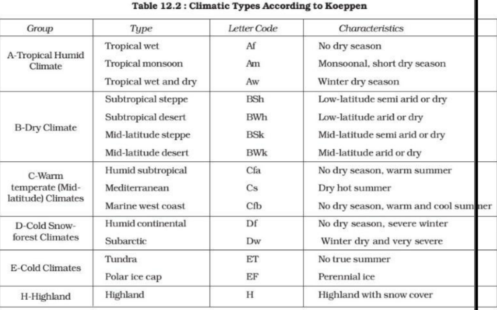
Classification of Climate
- Koeppen recognized five major climatic groups, four of them are based on temperature and one on precipitation.
- The capital letters : A, C, D and E delineate humid climates and B dry climates.
- The climatic groups are subdivided into types, designated by small letters, based on seasonality of precipitation and temperature characteristics.
- The seasons of dryness are indicated by the small letters : f, m, w and s, where f corresponds to no dry season, m – monsoon climate, w – winter dry season and s – summer dry season.
- The small letters a, b, c and d refer to the degree of severity of temperature.
1. Hot, Wet Equatorial Climate’, ‘Equatorial Rainforest Climate
- The regions are generally referred as „Equatorial Rainforests’, ‘Equatorial Evergreen Forests’, ‘Tropical Moist Broadleaf Forest.
Distribution
- Mostly between 5° N and S of Equator.
- Its greatest extent is found in the lowlands of the Amazon, the Congo, Malaysia and the East Indies.
Temperature
- Temperature is uniform throughout the year.
- The mean monthly temperatures are always around 27° C with very little variation.
- There is no winter
- Cloudiness and heavy precipitation moderate the daily temperature
- Regular land and sea breezes assist in maintaining a truly equable climate
- The diurnal range of temperature is small, and so is the annual range.
Precipitation
- Precipitation is heavy and well distributed throughout the year
- Annual average is always above 150 cm.
- In some regions the annual average may be as high as 250 – 300 cm.
- There is no month without rain.
- There are two periods of maximum rainfall, April and October. [shortly after the equinox].
- Least rain fall occurs in June and December [solstice].
Vegetation
- The equatorial vegetation comprises a multitude of evergreen trees that yield tropical hardwood, e.g. mahogany, ebony, dyewoods etc.
- Many parts of the tropical rain forests have been cleared either for lumbering or shifting cultivation.
- In the coastal areas and brackish swamps, mangrove forests thrive.
- All plants struggle upwards (most epiphytes) for sunlight resulting in a peculiar layer arrangement.
- Though the tropics have great potential in timber resources, commercial extraction is difficult.
- Multiple species of trees occur in a particular area (trees do not occur in homogenous stands or pure stands) making commercial exploitation a difficult task.
- Many of the tropical hardwoods (very heavy) do not float readily on water and this makes transportation an expensive matter
- It is therefore not surprising that many tropical countries are net timber importers.
Agriculture
- In the Amazon basin the Indigenous tribes collect wild rubber.
- In the Congo Basin the Pygmies gather nuts.
Soil
- The fertility of top soil in rainforest regions is very poor. Torrential downpours wash out most of the top soil nutrients [leaching or percolation and draining way of nutrients due to rain water action].
- The soil deteriorates rapidly with subsequent soil erosion and soil impoverishment.
- It takes decades to replenish the soil of lost nutrients.
2. Tropical Monsoon climate
Distribution
- Occur within 5° to 30° N and S of the equator.
- On-shore [sea to land] tropical monsoons occur in the summer and off-shore [land to sea] dry monsoons in the winter.
- They are best developed in the Indian sub-continent, Burma, Thailand, Laos, Cambodia, parts of Vietnam and south China and northern Australia.
Climate
- In the summer, when the sun is overhead at the Tropic of Cancer, a low pressure is created in Central Asia.
- The seas, which warm up much slower, remain comparatively at high pressure. At the same time, the southern hemisphere experiences winter, and a region of high pressure is set up in the continental interior of Australia.
- Winds blow outwards as the South-East Monsoon, to Java, and after crossing the equator are drawn towards the continental low pressure area reaching the Indian sub-continent as the South West Monsoon (Coriolis force).
- In the winter, conditions are reversed.
Temperature
- Monthly mean temperatures above 18 °C.
- Temperatures range from 30 – 45° C in summer.
- Mean summer temperature is about 30°C
- In winters, temperature range is 15-30° C with mean temperature around 20-25° C.
Rainfall
- Annual mean rainfall ranges from 200-250 cm. In some regions it is around 350 cm.
- Places like Cherrapunji & Mawsynram receive an annual rainfall of about 1000 cm.
Seasons
- Seasons are chief characteristics of monsoon climate
- Cool dry season (October to February)
- Hot dry season (March to Mid June)
- Rainy season (Mid June to September)
Vegetation
- Drought-deciduous forest dry /dry deciduous forest.
3. Savanna Climate or Tropical Wet and Dry Climate or Sudan Climate
- This type of climate has alternate wet and dry seasons similar to monsoon climate but has considerably less annual rainfall.
- Also, there is no distinct rainy season like in monsoon climate.
- Only two seasons – winter and summer.
- Rains occur in summer.
Distribution
- It is confined within the tropics and is best developed in Sudan, hence its name the Sudan Climate.
- It is a transitional type of climate found between the equatorial rain forests and hot deserts.
Rainfall
- Mean annual rainfall ranges from 80 – 160 cm [Rainfall decreases with distance from equator].
- Mean annual temperature is greater than 18° C.
- Days are hot and nights are cold. This extreme diurnal range of temperature is another characteristic feature of the Sudan type of climate.
Vegetation
- The savanna landscape is typified by tall grass and short trees.
- The grasslands are also called as ‘bush-veld’.
- The trees are deciduous, shedding their leaves in the cool, dry season to prevent excessive loss of water through transpiration, e.g. acacias.
Animals
- The savanna is known as the ‘big game country’ as thousands of animals are trapped or killed each year by people from all over the world.
- There are two main groups of animals in the savanna, the grass-eating herbivorous animals and the fleshing-eating carnivorous animals.
- The herbivorous include the zebra, antelope, giraffe, deer, gazelle, elephant etc.
4. Hot Desert Climate
- The aridity of the hot deserts is mainly due to the effects of off-shore Trade Winds , hence they are also called Trade Wind Deserts.
- The major hot deserts of the world are located on the western coasts of continents between latitudes 15° and 30°N and S.
Distribution
- They include the biggest Sahara Desert (3.5 million square miles), Great Australian Desert, Arabian Desert, Iranian Desert, Thar Desert, Kalahari and Namib Deserts.
- In North America, the desert extends from Mexico into U.S.A. and is called by different names at different places, e.g. the Mohave, Sonoran, Californian and Mexican Deserts.
- In South America, the Atacama or Peruvian Desert (rain shadow effect and off-shore trade winds) is the driest of all deserts with less than 2 cm of rainfall annually.
Rainfall
- Deserts, whether hot or mid-latitude have an annual precipitation of less than 25 cm.
- Causes of Hot deserts located between 20-30 degree.
- The hot deserts lie along the Horse Latitudes or the Sub-Tropical High Pressure Belts where the air is descending, a condition least favorable for precipitation of any kind to take place.
- The rain-bearing Trade Winds blow off-shore and the Westerlies that are on-shore blow outside the desert limits.
- Whatever winds reach the deserts blow from cooler to warmer regions, and their relative humidity is lowered, making condensation almost impossible
- There is scarcely any cloud in the continuous blue sky. The relative humidity is extremely low, decreasing from 60 per cent in coastal districts to less than 30 per cent in the desert interiors. Under such conditions, every bit of moisture is evaporated and the deserts are thus regions of permanent drought. Precipitation is both scarce and most unreliable.
- On the western coasts, the presence of cold currents gives rise to mists and fogs by chilling the on coming air. This air is later warmed by contact with the hot land, and little rain falls. The desiccating effect of the cold Peruvian Current along the Chilean coast is so pronounced that the mean annual rainfall for the Atacama Desert is not more than 1.3 cm.
Temperature
- There is no cold season in the hot deserts and the average summer temperature is high around 30°C.
- High diurnal temperature range is a typical feature of hot deserts. Average diurnal range varies from 14 to 25° Celsius.
- Frosts may occur at night in winter
Vegetation
- The predominant vegetation of both hot and mid-latitude deserts is xerophytic or drought resistant.
- This includes the cacti, thorny bushes, long-rooted wiry grasses and scattered dwarf acacias.
- Trees are rare except where there is abundant ground water to support clusters of date palms.
- Most desert shrubs have long roots and are well spaced out to gather moisture, and search for ground water.
- Plants have few or no leaves and the foliage is either waxy, leathery, hairy or needle-shaped to reduce the loss of water through transpiration.
- The seeds of many species of grasses and herbs have thick, tough skins to protect them while they lie dormant.
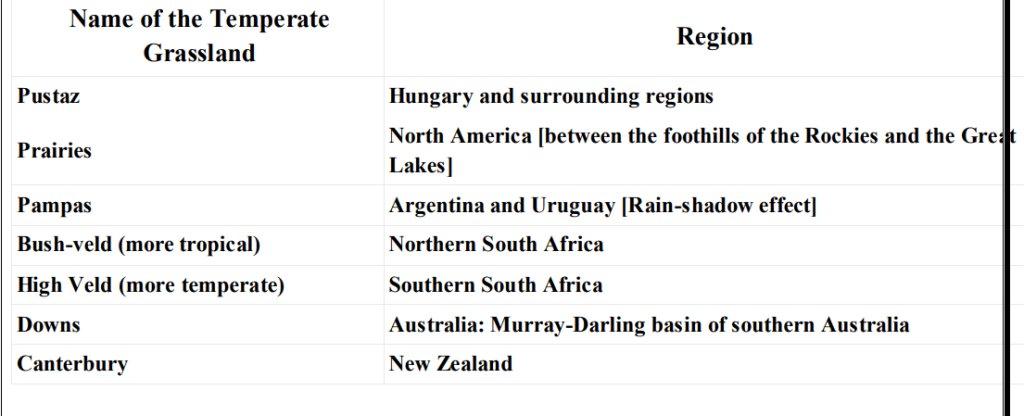
5. Steppe Climate or Temperate Continental Climate or Temperate Grassland Climate
Distribution
- They lie in the interiors of the continents.
- Lie in the Westerly wind belt [mid-latitudes or temperate region].
- Grasslands are practically treeless due to continentality
- In Eurasia, they are called the Steppes.
Temperature
- Climate is continental with extremes of temperature.
- Temperatures vary greatly between summer and winter.
- The summers are hot and the winters are cold
- Summers are very warm, over 18 – 20° C
Rainfall
- The average rainfall may be taken as about 45 cm, but this varies according to location from 25 cm to 75 cm.
- The heaviest rain comes in June and July (late spring and early summer).
- Most of the winter months have about an 2.5 cm of precipitation, brought by the occasional depressions of the Westerlies and coming in the form of snow.
- The maritime influence in the southern hemisphere causes more rainfall.
Chinooks [Snow eaters]
- On the eastern slopes of the Rockies in Canada and U.S.A. a local wind, similar to the Fohn in Switzerland, called the Chinook, comes in a south-westerly direction to the Prairies and has a considerable effect on the local pastures.
- It actually comes with the depressions in winter or early spring from the Pacific coast ascending the Rockies and then descending to the Prairies [katabatic wind].
- It is a hot wind and may raise the temperature by 5° C within a matter of 20 minutes.
- It melts the snow-covered pastures and animals can be driven out of doors to graze in the open fields. The agricultural year is thus accelerated.
- Local farmers welcome the Chinook for frequent.
Vegetation
- Grasses
- Greatest difference from the tropical savanna is that steppes are practically treeless and the grasses are much shorter
- Grasses are tall, fresh and nutritious. This is typical of the grass of the wheat-lands in North America, the rich black earth or chernozem areas of Russian Ukraine and the better watered areas of the Asiatic Steppes.
- Where the rainfall is light or unreliable, or the soil is poor, as in the continental interiors of Asia the short steppe type of grass prevails.
- The grasses are not only shorter but also wiry [lean, tough] and sparse [thinly dispersed or scattered].
- These areas are less suitable for arable farming and are used for some form of ranching as in the High Plains of U.S.A.
- The growth of grasses is not abruptly checked by summer droughts or winter cold.
- Trees
- Pole wards, an increase in precipitation gives rise to a transitional zone of wooded steppes where some conifers gradually appear.
- In the cultivated regions, such as the wheat farms of the Prairies, double rows of trees are planted around the house to shield the occupants from the strong wind.
6. Mediterranean Climate or Warm Temperate Western Margin Climate or Warm Temperate West Coast Climate
Distribution
- Entirely confined to the western portion of continental masses, between 30° and 45° north and south of the equator.
- The basic cause of this type of climate is the shifting of the wind belts.
- Mediterranean Sea has the greatest extent of this type of ‘winter rain climate’, and gives rise to the name Mediterranean Climate.
Climate
- Clear skies and high temperatures; hot, dry summers and cool, wet winters.
- Mean annual precipitation ranges from 35 – 90 cm.
Temperature
- Temperature of warmest month greater than or equal to 10⁰ C.
- Temperature of coldest month is less than 18⁰ C but greater than –3⁰ C
- Climate is not extreme because of cooling from water bodies
Rainfall
- The Mediterranean lands receive most of their precipitation in winter when the Westerlies shift equator wards.
- In the northern hemisphere, the prevailing on-shore Westerlies bring much cyclonic rain from the Atlantic (Typical to Mediterranean Climate).
Local winds
- Sirocco
- This is a hot, dry dusty wind which originates in the Sahara Desert.
- The Sirocco blows outwards in a southerly direction (south to north) from the desert interiors into the cooler Mediterranean Sea.
- After crossing the Mediterranean Sea, the Sirocco is slightly cooled by the absorption of the water vapor.
- This may be „blood rain‟ because the wind is carrying the red dust of the Sahara Desert.
- Mistral
- Mistral is a cold wind from the north, rushing down the Rhone valley.
- Bora
- A similar type of cold north-easterly wind experienced along the Adriatic coast is called the Bora.
Vegetation
- Trees with small broad leaves are widely spaced and never very tall.
- The absence of shade is a distinct feature of Mediterranean lands.
7. Warm Temperate Eastern Margin Climate/ China Type Climate
- Found between 20° and 35° N and S latitude (warm temperate latitudes just outside the tropics); on the east coast in both hemispheres.
Climate
- Characterized by a warm moist summer and a cool, dry winter.
- The mean monthly temperature varies between 4° C and 25° C and is strongly modified by maritime influence.
Rainfall
- Rainfall is more than moderate, from 60 cm to 150 cm.
8. British Type Climate or Cool Temperate Western Margin Climate
- The cool temperate western margins are under the influence of the Westerlies all-round the year.
- They are the regions of frontal cyclonic activity.
- Confined mainly to the coastlands of British Columbia , Southern Chile, Southern Australia, Tasmania and most parts of New Zealand.
Temperature
- The mean annual temperatures are usually between 5° C and 15° C.
- Winters are abnormally mild. This is because of the warming effect brought by warm North Atlantic Drift.
Rainfall
- The British type of climate has adequate rainfall throughout the year with a tendency towards a slight winter maximum (due to frontal cyclones).
- Western margins have the heaviest rainfall due to westerlies.
9. Laurentian Climate or Cool Temperate Eastern Marine Climate
- Intermediate type of climate between the British Type Climate (moderate) and the Taiga Type Climate (extreme) of climate.
- Laurentian type of climate is found only in two regions and that too only in the northern hemisphere .
- North-eastern North America, including eastern Canada, north-east U.S.A., and Newfoundland
- Eastern coastlands of Asia, including eastern Siberia, North China, Manchuria, Korea and northern Japan.
Distribution
- In the southern hemisphere only a small section of continents extends south of 40°S latitude.
Climates
- Characterized by cold, dry winters and warm, wet summers.
- Winter temperatures is below freezing-point and snow fall is quite natural.
Rainfall
- Rainfall occurs throughout the year with summer maxima.
- The predominant vegetation is cool temperate forest.
10. Boreal Climate OR Taiga Climate OR Siberian Climate OR Cool Temperate Continental Climate OR Continental Sub-Polar Climate
- Found only in the northern hemisphere [due to great east-west extent.
- Absent in the southern hemisphere because of the narrowness in the high latitudes].
- Experienced in the regions just below Arctic circle.
- On its poleward side, it merges into the Arctic tundra
- The climate fades into the temperate Steppe climate.
Distribution
- It stretches along a continuous belt across central Canada, some parts of Scandinavian Europe and most of central and southern Russian. [50° to 70° N]
Temperature
- Summers are brief and warm reaching 20-25 °C whereas winters are long and brutually cold – always 30-40 °C below freezing.
Precipitation
- Maritime influence in the interiors is absent.
- Frontal disturbances might occur in winter.
- Typical annual precipitation ranges from 38 cm to 63 cm.
Natural Vegetation of Taiga Climate
- Softwood Trees
- The predominant vegetation is evergreen coniferous forest.
Characteristics of Coniferous Forests
- Unlike the equatorial rain forests, Coniferous forests are of moderate density and are more uniform. The trees in coniferous forests grow straight and tall.
- Almost all conifers are evergreen.
- Conifers are conical in shape. Their conical shape and sloping branches prevent snow accumulation. It also offers little grip to the winds.
- Transpiration can be quite rapid in the warm summer. So, leaves are small, thick, leathery and needle-shaped to check excessive transpiration.
Lumbering in Taiga Region– Factors that favor lumbering:
- The conifers are limited in species. Pine, spruce and fir in the northern forests and larch in the warmer south are the most important.
- Unlike rainforests, they occur in homogeneous groups.
11. Tundra Climate or Polar Climate or Arctic Climate
Distribution
- Found in regions north of the Arctic Circle and south of Antarctic Circle.
- The ice-caps are confined to highlands and high latitude regions of Greenland and Antarctica.
Climate- Temperature :
- The tundra climate is characterized by a very low mean annual temperature.
- In mid-winter temperatures are as low as 40 – 50 °C below freezing.
- Summers are relatively warmer.
Precipitation
- Precipitation is mainly in the form of snow and sleet and being drifted about during blizzards.
Natural Vegetation
- There are no tress in the Tundra.
- Lowest form of vegetation like mosses, lichens, etc. are found.
Human Activities
- Human activities of the tundra are largely confined to the coast
- People live a semi-nomadic life.
- In Greenland, northern Canada and Alaska live the Eskimos.
- During winter they live in compact igloos.
Front
- When two different air masses with distinct properties (temperature, moisture, density, pressure etc.) meet, the boundary zone between them is called a front.
- These air masses are brought together by converging movements in the general atmospheric circulation.
- The process of formation of the fronts is known as frontogenesis while Frontolysis is the end stage of a front
- The fronts do not mix readily.
- They come in contact with one another along sloping boundaries.
Warm Front
- When a warmer and lighter air mass moves against an existing cold and dense airmass, it rises over the coldet and denser air mass.
- This type of front is known as warm front.
- As the warm air gradually ascends the gently sloping surface of the wedge of cold air lying ahead, it cools.
- This cooling leads to the cloudy condensation and precipitation.
- Unlike the cold front, the changes in temperature and wind direction are gradual.
Cold Front
- When a cold and dense airmass forces its way under warm and lighter airmass it makes the warm and lighter airmass to ride over it.
- This type of front is called cold front.
- The effect of friction retards the air motion near the ground, while the free air aloft has a higher velocity.
- This causes the cold front to become much steeper than the warm front.
Stationary Front
- A stationary front forms when a cold front or warm front stops moving.
- This happens when two masses of air are pushing against each other but neither is powerful enough to move the other.
Occluded Front
- A warm air mass pushes into a colder air mass (the warm front) and then another cold air mass pushes into the warm air mass (the cold front).
- Because cold fronts move faster, the cold front is likely to overtake the warm front. This is known as an occluded front.
- At an occluded front, the cold air mass from the cold front meets the cool air that was ahead of the warm front.
- The warm air rises as these air masses come together.
- Occluded fronts usually form around areas of low atmospheric pressure.
- The fronts occur in middle latitudes and are characterized by steep gradient in temperature and pressure.
- They bring abrupt changes in temperature and cause the air to rise to form clouds and cause precipitation.
- There are two types of occlusion namely, cold front occlusion and war front occlusion.