World Geography : Temperature, Distribution of Temperature and General Circulation of the Atmosphere. ( UPSC )
The temperature is the measurement of the degree of hotness.
Distribution of Temperature
- Horizontal distribution of temperature
- The distribution of temperature on the earth’s surface along the lines of latitude and longitude is called horizontal distribution of temperature.
- The distribution of temperature on the surface of the earth is not uniform.
- Factors responsible for the uneven distribution of temperature on the surface are:
- Latitude
- Heterogeneity of land and water
- Relief and elevation
- Ocean currents
- Winds
- Vegetation cover
- Nature of soil
- Slope and orientation of land
- Latitude
- The amount of insolation depends on the latitude of the place.
- At the equator sun’s rays fall directly overhead throughout the year.
- Away from the equator towards poles, the inclination of the Sun’s rays increases.
- Altitude
- Atmosphere is largely heated indirectly by re-radiated terrestrial radiation from the earth’s surface.
- Therefore, the lower layers of the atmosphere are comparatively warmer than the upper layers, even in the same latitudes.
- Heterogeneity of land and water
- Land surface is heated and cooled at a faster rate than the water surface.
- Thus the temperature of the air over land and water surfaces is not the same at a given time.
- In summers, the sea water is cooler than the land and in winters, land is much colder than the sea water.
- Ocean currents
- The effect of warm ocean currents and the cold ocean currents is limited to the adjoining coastal areas.
- Winds
- Winds helps in the redistribution of temperature.
- The places, which come under the influence of warm air-masses experience higher temperature and the places that come under the influence of cold air masses experience low temperature.
- Vegetation cover Latitude
- The amount of insolation depends on the latitude of the place.
- At the equator sun’s rays fall directly overhead throughout the year.
- Away from the equator towards poles, the inclination of the Sun’s rays increases.
- Altitude
- Atmosphere is largely heated indirectly by re-radiated terrestrial radiation from the earth’s surface.
- Therefore, the lower layers of the atmosphere are comparatively warmer than the upper layers, even in the same latitudes.
- Heterogeneity of land and water
- Land surface is heated and cooled at a faster rate than the water surface.
- Thus the temperature of the air over land and water surfaces is not the same at a given time.
- In summers, the sea water is cooler than the land and in winters, land is much colder than the sea water.
- Ocean currents
- The effect of warm ocean currents and the cold ocean currents is limited to the adjoining coastal areas.
- Winds
- Winds helps in the redistribution of temperature.
- The places, which come under the influence of warm air-masses experience higher temperature and the places that come under the influence of cold air masses experience low temperature.
- Vegetation cover
- Thick vegetation (such as Amazon forest) cuts off much of the in-coming insolation and in many places sunlight never reaches the ground.
- It is cool in the jungle and its shade temperature is a few degrees lower than that of open spaces in corresponding latitudes.
- Nature of surface
- In the tropical and subtropical deserts, the sandy surface record high temperature because they absorb most of the solar radiations.
- Snow has very high albedo and thus, reflects much of the insolation without absorption.
- Soil
- Light soils reflect more heat than darker soils. Dry soils like sands are very sensitive to temperature changes, whereas wet soils, like clay retain much moisture and warm up more slowly.
Slope and orientation of land
- Slopes of a mountain facing the Sun experiences high temperature than the slopes on the leeward side due to more insolation.
- A steep slope experiences a more rapid change in temperature than a gentle one.
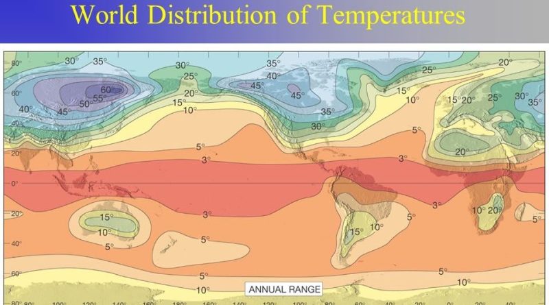
Isotherms
- The isotherms are the lines joining places having equal temperature.
Chief features of Isotherms
- The isotherms are generally parallel to equator.
- They show successive temperature decrease towards the poles.
- The rate of change of temperature is indicated by the spacing between isotherms.
- Closely drawn isotherms indicate rapid change in temperature and vice-versa.
- The isothermal lines have larger space on the oceans and become closer on the continents..
(A) Horizontal distribution of temperature (in January)
- In January the northern hemisphere, the air over the oceans is warmer than the continents, so here the isothermal lines bend towards the equator while crossing the continents and towards the poles while crossing the oceans.
- The position of isothermal lines in the Southern Hemisphere is just the opposite.
- They bend towards the poles while crossing the continents and the equator bends further when crossing the oceans.
(B) Horizontal distribution of temperature (in July)
- In July, high temperatures are found throughout the northern hemisphere.
- During the summer season in the northern hemisphere, the isothermal lines bend towards the equator while crossing the oceans and bend towards the poles while crossing the continents.
- The position of isothermal lines in the Southern Hemisphere is exactly opposite to that of the Northern Hemisphere.
Vertical distribution of temperature
- The temperature decreases with increasing altitude.
- Since the atmosphere is mainly heated by terrestrial radiation.
- Therefore, the layers of the atmosphere that are closer to the surface receive the most heat from the Earth and are the hottest.
- The temperature gradually decreases in the course of going up, with the increase in altitude, the rate of fall in temperature is 6.50C per 1000 m. (1 degree for every 165 meters) .
- This is called the normal lapse rate of temperature.
Diurnal range of temperature
- The range between extreme temperatures in a single day is called diurnal range of temperature.
- Air temperatures usually reach their minimum just before sunrise, because the ground has been giving off long-wave radiation all through the night, gradually becoming colder and cooling the air above by conduction.
- With sunrise, temperature of the ground begins to rise.
- Maximum insolation receives at midday. But the peak of air temperature is usually about 2:00 PM.
- After sun-set, the air initially remains fairly warm as it is still being heated by long-wave radiation from the ground, but this gradually expires.
- Desert areas typically have the greatest diurnal temperature variations while Low lying, humid areas typically have the least range.
Annual average range of temperature
- It is the monthly range of temperature or the difference between the average temperature of hottest month and average temperature of the coldest month of the year.
- The annual range is lower in low latitudes and higher in high latitudes.
- In the same latitudes, it is higher over the continents and lower over the oceans and coastal regions.
- The highest annual range of temperature is more than 60° C over the north-eastern part of Eurasian continent.
- This is due to continentality.
- The least range of temperature, 3°C, is found between 20° S and 15° N.
Temperature Belts
- The three major temperature belts of the Earth are:
- Tropical zone / Torrid zone
- Temperate Zone
- Frigid Zone
1. Tropical belt
- This is the hottest zone of the Earth
- In this heat zone, the sun’s rays fall almost vertically throughout the year.
- This heat zone is the widest zone.
- The tropics are situated between Tropic of Cancer (North) and Tropic of Capricorn (South).
- The Sun is also perpendicular to the Tropic of Cancer on 21st June and Capricorn on 22nd December.
2. Temperate
- The temperate zone is located on either side of the tropics.
- The northern temperate zone is situated in between the Tropic of Cancer (North) to the Arctic Circle (North).
- Here the duration of night in winter is longer than the duration of day and vice versa in summer.
3. Frigid Zone
- This zone is the coldest region in the world.
- Here there is always a thick layer of snow on the ground.
- The northern frigid zone is located between the Arctic Circle and the North Pole.
- The southern frigid zone is from the Antarctic Circle to the South pole.
- In the frigid zone, the sun’s rays always fall obliquely and their angle of incidence is very small.
- The poles have a day of 6 months in summer and a night of 6 months in winter.
Pressure System
- Air expands when heated and gets compressed when cooled.
- This results in variations in the atmospheric pressure.
- The differences in atmospheric pressure causes the movement of air from high pressure to low pressure, setting the air in motion.
- Atmospheric pressure also determines when the air will rise or sink.
- Air in horizontal motion is wind.
- The wind redistributes the heat and moisture across latitudes, thereby, maintaining a constant temperature for the planet as a whole.
- The vertical rising of moist air forms clouds and bring precipitation.
Pressure belts
- There are distinctly identifiable zones of homogeneous horizontal pressure regimes or pressure belts.
- On the earth’s surface, there are seven pressure belts.
- The seven pressure belts are :
1. Equatorial low pressure belt
- Lies between 10°N and 10°S latitudes.
- This belt is thermally produced due to heating by Sun.
- Due to excessive heating horizontal movement of air is absent here and only vertical currents are experienced in this belt.
- Therefore, this belt is called doldrums (the zone of calm).
- This belt is also known as-Inter Tropical Convergence Zone (ITCZ) because the trade winds flowing from sub tropical high pressure belts converge here.
2. Sub-tropical high pressure belt
- These extend roughly between 25 degree and 35 degree latitudes in both the Hemispheres.
- The existence of these pressure belts is due to the fact that the up rising air of the equatorial region is deflected towards poles due to the earth’s rotation.
- After becoming cold and heavy, it descends in these regions and get piled up.
- This results in high pressure.
- It is a Calm are with feeble and variable winds.
- In southern hemisphere, this belt is broken by small low-pressure areas in summer over Australia and South Africa.
- In northern hemisphere, the belt is more discontinuous by the presence of land masses, and high pressure occurs.
- only over the ocean areas as discrete cells – termed the Azores and Hawaiian cells in the Atlantic and Pacific areas respectively.
3. Horse latitudes
- These belts are also called Horse latitudes.
- In older days, vessels with cargo of horses passing through these belts found difficult in sailing under these calm conditions.
- They used to throw the horses in the sea in order to make the vessels lighter.
4. Sub-polar low pressure belt
- It extends along 600 latitudes (55 -65 degree ) in both the hemisphere
- These belts are dynamically induced due to this fact that the winds coming from the sub-tropics and the polar regions converge in this belt and rise upward.
5. Polar high pressure belt
- Because of low temperature, air compresses and its density increases.
- Hence, high pressure is found here throughout the year.
- This is more marked over the land area of the Antarctic continent than over the ocean of the North Pole.
- In northern hemisphere, high pressure is not centered at the pole, but it extends from Greenland to Islands situated in the northern part of Canada.
6. Shifting of Belts
- Pressure belts are not fixed.
- Pressure belts swing either to the north (in July) or the south (in December) of the equator by following the apparent annual migration of the sun.
- Sun’s movement is recorded between tropic of Cancer and tropic of Capricorn.
- During the month of July, low pressure equatorial belt extends up to the tropic of Cancer in Asian region.
- While in January, it extends to latitudes 10 -15 degree S.
- Most profound effect of shifting of belts is seen in the temperate region.
- Winds blowing from the Horse latitudes in the form of westerlies create unique climatic conditions in the temperate parts of the world, especially in the Mediterranean region.
General Circulation of the Atmosphere
Largely, wind movement in the atmosphere may be classified into three broad categories.
- Primary circulation
- It includes planetary wind systems which are related to the general arrangement of pressure belts on the earth’s surface
- Secondary circulation
- It consists of cyclones and anti-cyclones, monsoon
- Tertiary circulation
- It includes all the local winds.
Planetary Winds
- Primary or planetary winds blow from high pressure belts to low pressure belts in the same direction throughout the year.
- They blow over vast area of continents and oceans.
- Trade winds, Westerlies and polar easterlies together form the planetary wind circulation.
Tropical easterlies or trade winds
- The trade winds are those blowing from the sub-tropical high pressure areas towards the equatorial low pressure belt.
- Therefore, these are confined to a region between 30°N and 30°S throughout the earth’s surface.
- They flow as the north-eastern trades in the northern hemisphere and the south-eastern trades in the southern hemisphere.
- This deflection in their ideally expected north-south direction is explained on the basis of Coriolis force and Farrel‟s law.
Westerlies
- The westerlies are the winds blowing from the sub-tropical high pressure belts towards the sub polar low pressure belts.
- They blow from southwest to north-east in the northern hemisphere and north-west to southeast in the southern hemisphere.
Variability of Westerlies
- The prevailing westerlies are relatively more variable than the trade winds both in direction and intensity.
- The westerlies are stronger in the cold.
- In the southern hemisphere, westerlies are so powerful and persistent due to absence of land between 40 -60 degree S that these are called „roaring forties‟, „furious fifties‟ and „screaming sixties‟ along 40 degree S, 50 degree S and 60 degree S latitudes.
Polar easterlies
- Winds move away from polar high pressure to sub-polar low pressure along the surface of the earth in Polar cell.
- Their direction becomes easterlies due to Coriolis force.
- These are called polar easterlies.
Local Winds
- There are certain types of winds which are produced by purely local factors and therefore, are called local winds.
- These local winds play a significant role in the weather and climate of a particular locality.
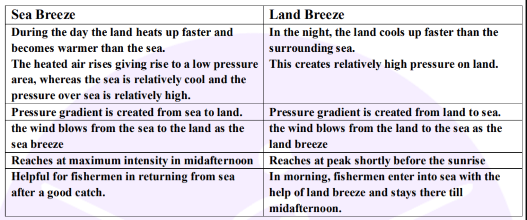
The Valley Breeze
- During the day the slopes get heated up more than the valleys.
- Hence, the pressure is low over the slopes while it is comparatively high in the valleys below.
- Air moves up from slope and to fill the resulting gap the air from the valley blows up the valley
- This wind is known as the valley breeze or anabatic wind.
- The valley breeze is accompanied by the formation of cumulus cloud near mountain peaks to cause orographic rainfall.
The Mountain Breeze
- During the night the slopes get cooled and the dense air descends into the valley as the mountain wind.
- The cool air, of the high plateaus and ice fields draining into the valley is called mountain breeze or katabatic wind.
Hot Local Winds
- Loo
- “Loo” is a hot and dry wind, which blows very strongly over the northern plains of India and Pakistan in the months of May and June.
- Their direction is from west to east and they are usually experienced in the afternoons.
- Their temperature varies between 45°C to 50°C.
- Foehn
- “Foehn” is strong, dusty, dry and warm local wind which develops on the leeward side of the Alps mountain ranges.
- Ascending air sometimes causes precipitation on the windward side of the mountains
- After crossing the mountain crest, the Foehn winds starts descending on the leeward side or northern slopes of the mountain as warm and dry wind.
- The temperature of the winds varies from 15°C to 20°C which help in melting snow.
- Thus making pasture land ready for animal grazing and help the grapes to ripe early.
- Chinook
- “Chinook” is the name of hot and dry local wind, which moves down the eastern slopes of the Rockies in U.S.A. and Canada.
- The literal meaning of chinook is „”snow eater” as they help in melting the snow earlier.
- They keep the grasslands clear of snow.
- Hence, they are very helpful to ranchers.
- Sirocco
- “Sirocco” is a hot, dry dusty wind, which originates in the Sahara desert.
- It is most frequent in spring and normally lasts for only a few days.
- After crossing the Mediterranean sea, the Sirocco is slightly cooled by the moisture from the sea.
- Still it is harmful for vegetation, crops in that region.
- Its other local names are Leveche in Spain, Khamsin in Egypt, Gharbi in Aegean Sea area.
- Harmattan
- Harmattan is a strong dry wind that blows over northwest Africa from the northeast.
- Blowing directly from the Sahara desert, it is a hot, dry and dusty wind
- It provides a welcome relief from the moist heat and is beneficial to health of people hence also known as “the doctor”.
- It is full of fine desert dust which makes the atmosphere hazy and causes problems to the caravan traders.
- It may cause severe damage to the crops.
Cold Local Winds
- Mistral
- “Mistral” originates on the Alps and move over France towards the Mediterranean Sea through the Rhone valley.
- Bora
- “Bora” is a cold, dry north-easterly wind blowing down from the mountains in the Adriatic Sea region.
- It is also caused by pressure difference between continental Europe and the Mediterranean Sea.
- This is usually occurs in winter
- Blizzard
- “Blizzard” is a violent and extremely cold wind laden with dry snow.
- Such blizzards are of common occurrence in the Antarctic
Upper Air Circulation
- Hadley Cell
- The air at the Inter Tropical Convergence Zone (ITCZ) rises because of convection caused by high insolation and a low pressure is created.
- The winds from the tropics converge at this low pressure zone.
- The converged air rises along up
- It reaches the top of the troposphere up to an altitude of 14 km and moves towards the poles.
- Due to cooling air sinks to the ground and forms a subtropical high.
- This air flows towards the equator as the tropical easterlies or trade winds.
- The easterlies from either side of the equator converge in the Inter Tropical Convergence Zone (ITCZ)
- Thus, winds originated at ITCZ come back in a circular fashion and form a cell called as Hadley Cell
- Ferrel cell and Polar cell
- In the mid latitudes (30 -60 degree) warm air that blows from the subtropical high pressure belt towards sub polar low pressure belt deflected due to Coriolis force and become westerly in both the hemisphere.
- Westerlies meet along the sub-polar low pressure belt to raise high in the troposphere
- From here, air moves away in both directions – towards pole and equator
- These winds start descending down above the sup-tropical high pressure belt and polar high pressure belt to form cells
- These cells are called Ferrel cell and Polar cell respectively.
Jet Streams
- The Jet Stream is a geostrophic wind blowing horizontally through the upper layers of the troposphere, generally from west to east, at an altitude of 20,000 – 50,000 feet.
- Jet Streams develop where air masses of differing temperatures meet.
- It was found in 1940s during Second World War that high-flying aircraft encountered upper winds of very great velocity.
Features of jet streams are
- These are narrow belts at the high altitude near the top of the troposphere.
- Their speed varies from about 110 km per hour (kmph) in the summer season to more than 180 kmph in the winter season.
- Their shape is circular.
- Speed in the jet streams decreases radially outwards.
- Their circulation path is wavy and meandering.
- These meandering winds are called Rossby waves.
Types of Jet Streams
- Two permanent jet stream zones occur in each hemisphere.
- One is sub-tropical jet stream and another is polar front jet stream.
- Sub-tropical jet stream
- It runs between 25 and 30 degree latitudes in both the hemispheres.
- It blows constantly.
- Its speed is comparatively lower than polar jet streams.
- The air currents arising near about the equator descend at 30 degree N and S latitudes.
- A part of these air currents takes the form of Sub Tropical Jet streams.
- It swings to the north of Himalayas in summer in North India.
- The polar front jet stream
- It is originated because of temperature difference.
- It is associated with the polar front zone in each hemisphere.
- It runs at a more meandering path than the Sub Tropical Jet Stream.
- It extends between 40 and 60 latitudes in both Hemispheres.
- It is found at a height between 6km and 9km in the atmosphere.
- It swings towards poles in summers and towards equator in winter.
- When swinging to south it takes very cold air with it to subtropical region.
- Eastern Tropical Jet Stream
- It is a seasonal Jet Stream.
- It blows between equator and 20 degree N latitude at the time of South-West Monsoon in summer over south-east Asia, India and Africa.
- It’s direction is opposite to that of other two jet streams.
- It runs in eastern direction.
- It is located comparatively at higher height between 14km and 16km.
- Its speed is around 180 km per hour.
Climatic Significance of Jet Stream
- At times, Jet Streams bring about some moisture to the stratosphere, leading to the formation of Noctilucent clouds known to have brought some ozone depleting substances to stratosphere which result in ozone layer depletion.
- Intensifies alternative cyclonic and anticyclonic conditions with the crust and trough formation in its movement.
- When the air mass is moving, it undergoes alternate expansion and compression which means that it is associated with alternative high pressure and low pressure.
Temperature inversion
Increasement of temperature with increasing altitudes is called inversion of temperature or thermal inversion.
Surface or low-level inversion (Ground inversion)
- Terrestrial radiation inversion (Radiational inversion)
- After sunset, due to the terrestrial radiation from the surface, there is a rapid dissipation of heat, due to which the terrestrial surface becomes quite cold during the night.
- The layers of air adjoining the surface quickly become very cold by the processes of radiation and conduction.
- The upper layers of air are less affected by this process of cooling than the lower layers.
- Therefore, the temperature of the upper air remains higher than the air near the surface.
- The following are the favorable conditions for the generation of low level temperature inversion of radiation
- Long winter nights
- Cloudless sky or high-level clouds,
- Dry air
- Low wind velocity
- Surface covered by snow
- Low level temperature-inversion is fully developed in mountainous or mountainous regions in their valleys.
- During the long winter nights, mountain slopes become extremely cold by radiation, due to which the temperature of the air layers surrounding them also drops significantly.
- At the same height the air away from the slopes is relatively warm.
- Therefore, when the sky is clear at night, the cold and heavy winds in the hill slopes move away from the valleys due to the effect of gravity.
- In winter, in these valleys, on calm and clear nights, there is severe frost, which proves to be very harmful for the crops.
- Therefore, the trees is planted at some height on the slopes in the valleys.
- Advection inversion
- Whenever hot air passes over cold air, a state of inversion of convection is observed.
- Upper air inversion
- Subsidence inversion
- It is found in subtropical areas.
- It originates due to subduction of air from the stratosphere and heating due to adiabatic temperature change
- Turbulence and convective inversion
- Convectional current flows in the stratosphere due to irregular heating of the surface.
- In this sequence the cold air rising up and the air coming down gets hot.
- Due to such mixing of air for a long time, the air in the upper part of the mixing zone will become colder than before.
- Subsidence inversion
- Frontal inversion
- Sometimes in the case of cold front, the cold air mass force the warm air mass upwards, causing a situation of frontal inversion.
- In the warm front zone, when the warm air mass rises above the cold air zone, then the front itself turns into the reversal zone where temperature increases with altitude.
- The marginal regions of frontal inversion are not horizontal but have a slope.
- This is due to the Coriolis force.