Tropical Storm Douglas ‘expected to become a hurricane soon’ as it heads toward Central Pacific
Tropical Storm Douglas ‘expected to become a hurricane soon’ as it heads toward Central Pacific
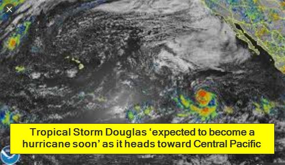
UPDATE: 10:55 p.m. Tuesday
Tropical Storm Douglas maintained its strength and is “expected to become a hurricane soon,” according to the National Weather Service in Miami.
The storm’s five-day forecast has Douglas threatening the Big Island as a tropical storm with maximum sustained winds of 60 mph by Sunday.
Just before 11 p.m. Tuesday, Douglas was 1,875 miles east-southeast of Hilo with maximum sustained winds of 65 mph, moving west at 14 mph.
“Strengthening is forecast during the next couple of days, and Douglas is expected to become a hurricane on Wednesday,” forecasters said.
Tropical storm-force winds extend up to 80 miles from the center of Douglas.
Forecasters predict the storm will peak as a Category 2 hurricane with maximum sustained winds of 105 mph on Thursday as it approaches the Central Pacific.
However it is expected to weaken back to a tropical storm by Saturday as it nears the eastern Big Island.
UPDATE: 4:55 p.m.
Tropical Storm Douglas in the eastern Pacific continued to strengthen this afternoon and is forecast to be a hurricane tonight or Wednesday, according to the National Weather Service in Miami.
Just before 5 p.m. today, Douglas was 1,955 miles east of Hilo with maximum sustained winds of 65 mph, moving west at 14 mph.
Douglas is expected to turn toward the west-northwest and accelerate late Wednesday. Tropical storm-force winds extend up to 80 miles from the storm’s center.
Forecasters predict the storm will peak as a Category 2 hurricane with maximum sustained winds of 105 mph on Thursday as it approaches the Central Pacific.
A gradual weakening is then expected, but the weather service’s current five-day storm track still has Douglas as a tropical storm with maximum sustained winds of 60 mph just 137 miles east of Hilo on Sunday afternoon.
[amazon box=”B07H97FRX5″ “small”]
UPDATE: 2:30 p.m.
Gov. David Ige and Hawaii Emergency Management Agency Administrator Luke Meyers discuss hurricane preparedness while Hawaii continues to deal with the COVID-19 pandemic. They’ll also answer questions on Facebook live.
Watch the live-stream above.
UPDATE: 2 p.m.
Honolulu Mayor Kirk Caldwell today urged Oahu residents to ensure they are stocked with two-week hurricane preparedness kits up as Tropical Storm Douglas approaches the Hawaiian Islands.
The storm is expected to strengthen and become a hurricane in the coming days. The National Hurricane Center’s five-day forecast has Douglas entering the Central Pacific on Friday as a hurricane but weakening to a tropical storm with maximum sustained winds of 60 mph by early Sunday, about 249 miles east-southeast of Hawaii island.
In the wake of the COVID-19 pandemic, the city Department of Emergency Management has already been looking reevaluating its shelter plan in the event people need to move out of their homes.
“We need to be ready,” Caldwell said. “We’re in hurricane season and if we have to evacuate, we need to find shelter space sufficient to handle folks who are going to move into shelters, hopefully, with their COVID-19 kits of hand sanitizers and face coverings and everything else.”
The six-foot social distancing recommendation spurred by the coronavirus pandemic creates “additional challenges” for the city, the mayor said.
Jennifer Walter, Emergency Management deputy director, said her agency has already over the past several months been looking into how to restructure its emergency preparedness strategy in a pandemic situation.
“We are looking at new places that could serve as shelters that we don’t traditionally use,” Walter said. “We kicked off a project this week to identify best available refuge areas which is going to provide engineering assessments of 150 facilities during hurricane season.”
She added: “We are trying to do 6 feet in between family units so that does have impacts on our capacity.”
Walter said another potential source of concern is proper staffing of shelters during a pandemic and she urged people to volunteer with the Red Cross. Many volunteers tend to be retirees, and they may not be available to help during the outbreak.
Emergency Management is also working with the state Department of Health and the American Red Cross to come up with guidelines for the use of personal protective equipment (PPEs) and screening for those entering shelters, Walter said. “We’re actively putting together kits of personal protective equipment for every shelter.”
Shelters will need to have classroom space available for those who are symptomatic for COVID-19 and need to be isolated, she said.
Screening will likely consist of “a fairly quick and simple process” that’s similar to what is in place at Hawaii airports, Walter said.
“It would be a simple temperature check and then some questions about people’s recent travel histories, things like that,” she said. “If someone expresses that they have a symptom or they have a fever, they would be referred to a health care professional that would be at the shelter to make a determination about whether or not they should be isolated within the shelter from an area away from the rest of the shelter occupants.”
Caldwell said he is working on an Oahu-wide card to help those in need be able to purchase 14 days worth of food with restrictions such as no alcohol or tobacco. “We don’t have it in place at this time, but it’s something hard we are trying to get done,” he said.
He provided no further details.
11:15 a.m.
At 11 a.m., Tropical Storm Douglas was located about 2,035 miles east-southeast of Hilo packing maximum sustained winds of 65 mph while moving west-southwest at 15 mph, according to the National Hurricane Center in Miami.
”Strengthening is forecast during the next couple of days, and Douglas could become a hurricane later today or tonight,” forecasters said. Douglas is expected to turn toward the west and slow its advance slightly this evening.
Tropical-storm-force winds extend outward up to 80 miles from the center.
PREVIOUS COVERAGE
Although they’re both still headed toward the central Pacific, tropical depression Seven-E has weakened to a remnant low while Tropical Storm Douglas has grown to near hurricane strength.
At 5 a.m. today, Tropical Storm Douglas packed maximum sustained winds near 65 mph and was located about 2,105 miles east-southeast of Hilo while moving toward the west-southwest at 15 mph, according to the National Hurricane Center in Miami. Tropical-storm-force winds extend outward up to 35 miles from Douglas’ center.
“Additional strengthening is forecast during the next several days, and Douglas could become a hurricane later today,” forecasters said. The storm is expected to start making a turn toward the west later today.
[amazon box=”B07DQTFX6F” “small”]
The latest forecast has Douglas becoming a hurricane later today with maximum sustained winds of 80 mph, and growing to a strong Category 1 hurricane with maximum sustained winds of up to 105 mph by Thursday morning.
The National Hurricane Center’s five-day forecast has Douglas entering the Central Pacific on Friday as a hurricane but weakening to a tropical storm with maximum sustained winds of 60 mph by early Sunday, about 249 miles east-southeast of Hawaii island.
Also at 5 a.m. today, post-tropical cyclone Seven-E was located about 1,360 miles east of Hilo with maximum sustained winds of 35 mph and was moving west at 13 mph, according to the NHC. The remnant low is expected to continue to weaken, dissipating Wednesday or Wednesday night,
In the general weather forecast for Hawaii, warmer, wetter weather is in store for Hawaii for the next few days.
Tradewinds are expected to ease up today and Wednesday as an upper-level low drifts north of the islands, disrupting the cooling breezes until their expected return Thursday, forecasters said. Meanwhile, showers are expected to increase starting Wednesday
Tropical depression near tropical storm strength in Atlantic
MIAMI – A tropical depression in the middle of the Atlantic Ocean is close to tropical storm strength, though forecasters weren’t predicting a landfall location.
The U.S. National Hurricane Center said the depression was centered Wednesday morning about 1,285 miles (2,068 kilometers) east of the Southern Windward Islands. At 5 a.m. EDT, it had maximum sustained winds of 35 mph (56 kph) and was moving west-northwest at 12 mph (19 kph).
Forecasters said it could reach tropical storm status sometime on Wednesday. There were no coastal watches or warnings for the depression.
The depression could set a record for the earliest named seventh tropical storm of the Atlantic hurricane season if it strengthens into Tropical Storm Gonzalo before Friday. Tropical Storm Gert formed on July 24, 2005, making it the current record holder. So far this year, Cristobal, Danielle, Edouard and Fay have all set records for being the earliest named stormed of their respective place in the alphabet