World Geography : Causes and Types of Earthquakes & Volcanos. ( UPSC )
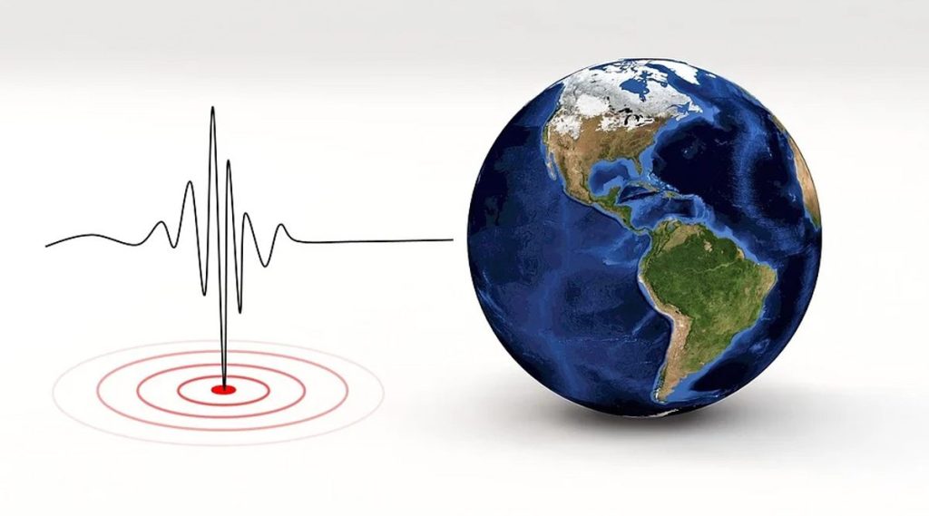
Shaking or trembling of the earth‟s surface, caused by the seismic waves
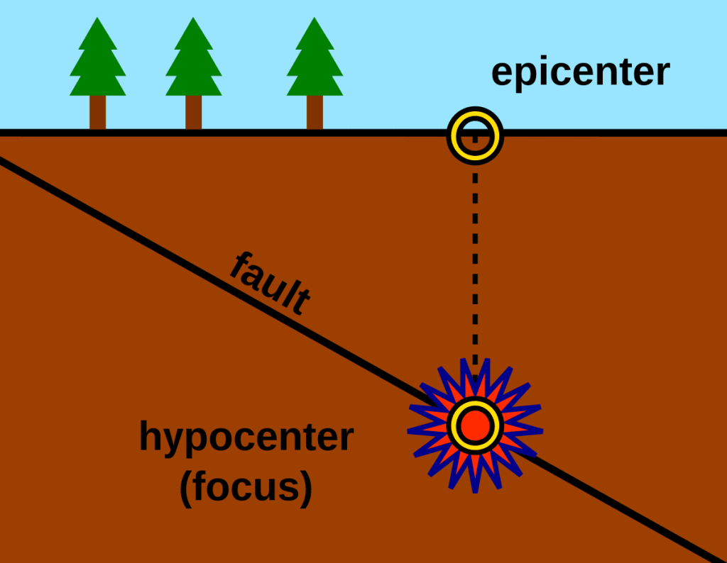
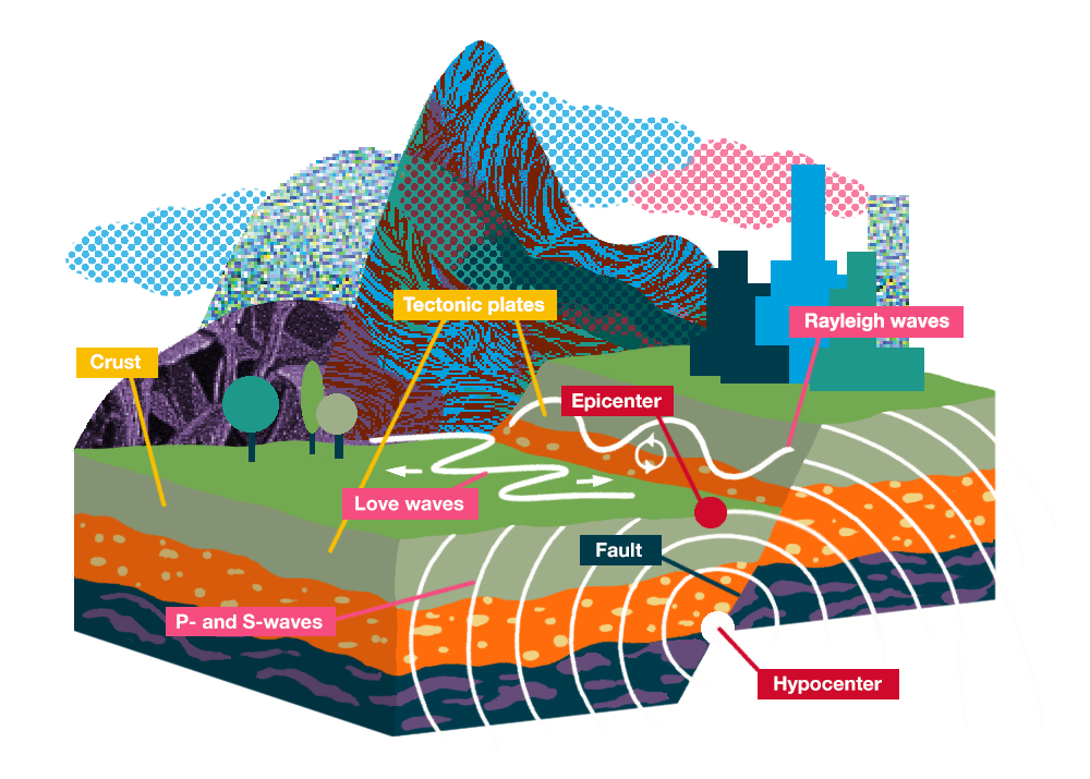
Center/Focus/Hypocenter
- The point from where the energy is released is called the focus of an earthquake.
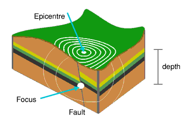
Epicenter
- The point vertically above the focus on the earth s surface is known as epicenter.
- Epicenter is point on surface lies nearest to the focus that’s why first surface point to experience the earthquake waves.
- Intensity is the highest at the epicenter.
- That is why the maximum destruction occurs at and around the epicenter.
- The intensity of vibrations decreases as one moves away from the epicenter.
Isoseismal line
- A line connecting all points on the surface where the intensity is the same is called an isoseismic line.

Homoseismal line
- The line joining the places of earthquake waves arising at the same time is called co-seismic line.
Causes of the Earthquake
Natural causes

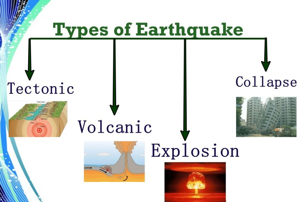
1. Volcanic action
- In volcanic action, fast and fast gases and vapors exert force to come out of the surface, due to which earthquakes are generated on the earth’s surface.
2. Plate Tectonic Theory
- Slipping of land along the faultline along convergent, divergent and transform boundaries cause earthquakes.
3. Exogenic forces
- An earthquake may also be caused due to landslide and collapse of cave or mines etc. which can cause a sudden release in energy.
Manmade causes
1- Reservoir Induced earthquake
- Underground rocks bend under pressure.
- When the bending exceeds a limit, the rocks break and try to return to their former position, due to which an earthquake is experienced.
2- Nuclear test
- Ground shaking may also occur due to the explosion of chemical or nuclear devices.
3- Mining
4- Unscientific infrastructural construction
Types of earthquake
A. Depending on the location of the earthquake
1. Shallow earthquakes
- Due to the decrease in pressure at the divergent boundary of the plates, the magma of the inner parts rises at a slow rate, which causes shallow earthquakes.
- These are 0-70 km deep.
- More than 90 percent of earthquakes in nature are of this type.
2. Intermediate earthquakes
- These are 70-300 km deep.
3. Deep Center Earthquakes
- These are 300-700 km deep.
Benioff zone
- It is a zone of subduction, along which earthquakes are common, which are produced by the interaction of a downgoing oceanic crustal plate against a continental plate.
- Deep earthquakes (300-700 km) are produced in this zone.
B. Depending on the earthquake
1. Terrestrial earthquake
- This type of earthquake occurs on the continental part.
2. Oceanic earthquakes
- These types of earthquakes occur in the ground of the sea.
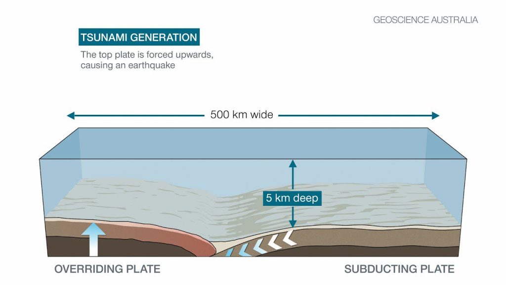
- The waves produced by these ocean earthquakes are called tsunamis. Their number is less as compared to local earthquakes.
Distribution of Earthquakes
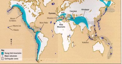
- Pacific Ocean
- Mid Continental Belt
- Mid-Atlantic Belt
- IntraPlate Belt
Pacific oceanic belt
- This is world’s greatest earthquake belt found along the rim of the Pacific Ocean.
- About 65 percent of the world’s earthquakes occur here.
Responsible factors
- Meeting point of ocean and land.
- Area of new fold mountains.
- Volcanic Zone.
- Convergence Zone of destructive Plates.
Mid continental plate or Alpide earthquake belt
- It extends from Java to Sumatra through the Himalayas, the Mediterranean, and out into the Atlantic.
- About 21 percent of earthquakes in the world occur in this region.
Mid-atlantic ridge
- The ridge marks where two tectonic plates are spreading apart (a divergent plate boundary.
- Most of the mid-Atlantic Ridge is deep underwater and far from human development.
IntraPlate range
- Occurs within the interior of a tectonic plate.
Effects of Earthquake
- Earthquakes are a natural hazard. If a tremor of high magnitude takes place, it can cause heavy damage to the life and property of people. The following are the immediate hazardous effects of earthquake:
- Ground Shaking.
- Differential ground settlement.
- Land and mudslides.
- Fires
- Ground lurching
- Avalanches
- Ground displacement
- Floods from dam and levee failures
- Structural collapse
- Tsunami
Scale for measurement of Earthquake
1. Richter Scale (1935)
- It is also called magnitude scale.
- It measures the energy released by an earthquake.
- It has a measuring scale from 1 to 10.
- On each scale 100 times more energy is released.
2. Mercalli Scale(1902)
- It is also called intensity scale.
- It measures the impact of an earthquake on the surface.
- It has a measuring scale from 1 to 12.
Major earthquakes
- Koyna in 1967.
- Latur, Maharashtra in 1993.
- 26 January 2001 in Bhuj, Gujarat.
- On March 11, 2011, the Earth’s rotation distance increased by 16 microseconds, the Earth’s rotation speed increased by 16 microseconds, due to the earthquake in Japan, the duration of the day was microseconds.
Tsunami
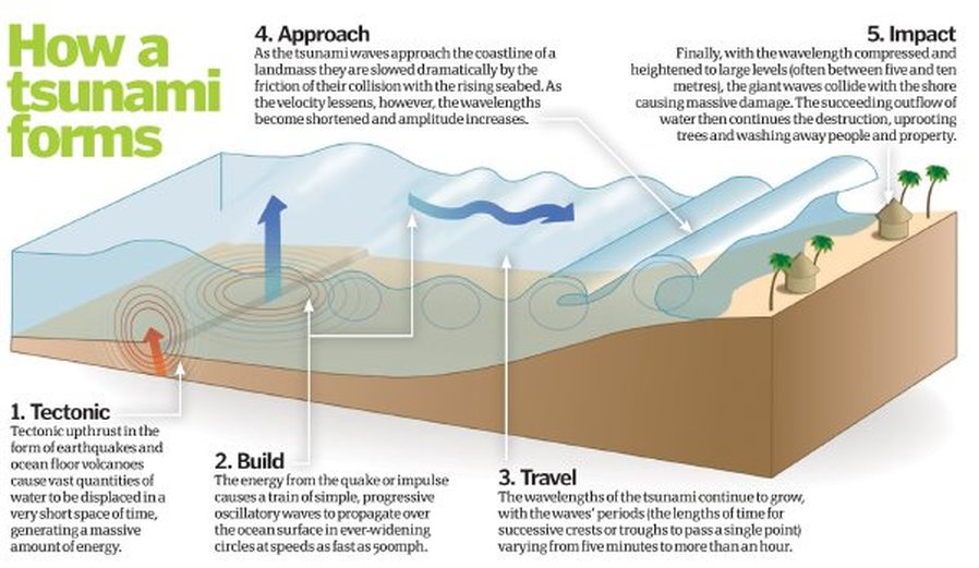
- The word tsunami is derived from the Japanese words su (port) and nami (wave).
- These are long wavelength and low frequency sea waves.
Causes of tsunami origin
- Earthquake
- Volcano
- Landslide
- Meteorite
Characteristics of tsunami
- Tsunami waves have the longest wavelength in deep seas, which decreases as they move towards the coast.
- As the depth of the ocean water decreases, the height of the tsunami increases. This is the reason why tsunamis are not visible in the open oceans.
- With the decrease in speed, the height of the tsunami wave grows. A tsunami which was imperceptible in deep water may grow to many meters high, and this is called the „shoaling‟ effect.
- The speed of tsunami is high in deep water whereas the speed of tsunami decreases when the depth of water is less.
- Sea water retreats rapidly before the arrival of tsunami waves in coastal areas.
- Tsunami waves are mostly born in the Pacific Ocean.
- The Sumatra tsunami on 26 December 2004 is the most devastating tsunami ever.
- On March 11, 2011, Japan was hit by a tsunami with the highest magnitude of the century, causing massive destruction and radioactive material leaks from the Fukushima Daiichi nuclear device explosion.
Volcano
A volcano is a vent or a fissure in the crust from which lava (molten rock), ash, gases, rock fragments erupt from a magma chamber below the surface.
Factors that lead to volcanism
Plate Tectonics
- The majority of volcanoes occur where two lithospheric plates converge and one overrides the other, forcing it down into the mantle to be reabsorbed.
Ocean floor spreading
- A major site of active volcanism is along the axis of the oceanic ridge system, where the plates move apart on both sides of the ridge and magma wells up from the mantle.
Weak Earth Surface
- Because of high pressure in the earth’s interior, the magma and gases escape with great velocity.
Faults
- Whenever extreme pressure builds in the mantle, along fault lines an eruption is likely to happen next. The earthquakes, for instance, may expose fault zones through which magma may escape.
A decrease in external pressure
- A decrease in external pressure can trigger an eruption as it may minimize the volcano’s ability to hold back by increasing the pressures inside the magma chamber.
Volcanism
- Volcanism is the eruption of molten rock (magma) onto the surface of a planet.
Products of volcanism
- All three types of substances, gas, fluid and solid, erupt from the volcano.
Gasses
- Many types of gases are released during volcanic eruption.
- e.g. hydrogen sulfide, carbon dioxide sulfide, ammonium chloride, hydrochloric acid.
- The amount of water vapour is the highest (60 – 90%) among the gases.
- As soon as the water vapour comes in contact with the atmosphere, it cools down and causes torrential rain.
Fluid substance
- The fluid erupt from the volcano is called lava.
- The temperature of freshly ejected lava is 600 °C to 1200 °C.
- The speed of a lava flow depends on its chemical composition and the slope of the land.
- Acidic lava (containing silica) is thick and viscous while alkaline lava (containing iron) is liquid.
Acidic lava
- These lavas are highly viscous with a high melting point.
- They are light-coloured, of low density, and have a high percentage of silica.
- They flow slowly and seldom travel far before solidifying.
- The rapid solidifying of lava in the vent obstructs the flow of the out-pouring lava, resulting in loud explosions, throwing out many volcanic bombs or pyroclasts.
- Andesitic lava flow occurs mostly along the destructive boundaries (convergent boundaries).
Basic or Basaltic or Sheild Lava
- They are dark colored basalt, rich in iron and magnesium but poor in silica.
- They flow out of volcanic vent quietly and are not very explosive.
- Due to their high fluidity, they flow readily with a speed of 10 to 30 miles per hour.
- They affect extensive areas, spreading out as thin sheets over great distances before they solidify.
- The resultant volcano having gentle slope with a wide diameter and forms a flattened shield or dome.
- Shield type lava flow is common along the constructive boundaries (divergent boundary).
Solid material
- Most of the lava cooled before it reaches the surface.
- With the next volcanic eruption, this condensed lava comes out in the form of solid which includes dust particles and ash.
- Apart from this, pea-sized lapilli and tufts (particles deposited in the ocean) also erupt.
Distribution of volcanoes based on plate tectonics
1- Circum-Pacific ring of fire
- Most of the high volcanic cones and volcanic mountains are found in this belt.
- About 70 per cent of earthquakes occur in this belt.
- Where there is active subduction of the Pacific, Nazca, Cocos, and juan de fuca plates.
- Other example is the volcanoes of Sumatra and Java, which lies over the subduction zone between the Australian plate and the Eurasian plate.
2- Mid-Atlantic belt
- A few basaltic volcanoes of fissure eruption type also occur along the mid-oceanic ridge, where seafloor spreading is in progress.
3- Mid-Continental belt
- It includes volcanoes of the alpine mountain chains and the Mediterranean Sea and those in the fault zone of Eastern Africa.
- Here volcanoes are caused due to collision of African, Eurasian and Indian plates.
4- Intra-plate volcanoes
- Some volcanoes are scattered in the inner parts of plates away from the margins.
- There are also called Hot spot volcanoes as they occur in the middle of plate boundaries where magma exits from weaknesses in the earth’s surface.
- The Hawaiian Islands are an example of hot spot volcanoes.
Types of Volcanoes
1. According to the explosivity
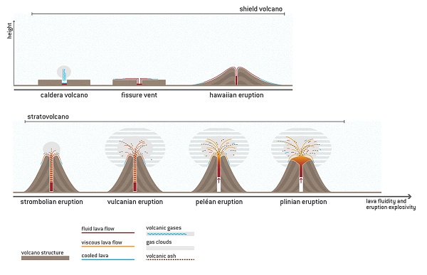
a) Hawaiian Volcano
- They are the calmest types characterized by the effusive eruption of very fluidish basalt-type lava.
b) Strombolian Type
- More explosive than the Hawaiian type.
- Example – Stromboli (Italy).
c) Vulcanian Type
- In Vulcanian eruptions, intermediate viscous magma within the volcano makes it difficult for gases to escape.
- This leads to the build-up of high gas pressure, eventually resulting in an explosive eruption.
- They are also more explosive than their Strombolian.
- Example – Vulcano (Italy).
d) Peléan
- In Peléan eruptions, a large amount of gas, dust, ash, and lava fragments are blown out the volcano’s central crater.
- Example – Pelee (France).
e- Vesuvius or Plinian Type
- Most Explosive.
- Example –Vesuvius (Italy).
2. According to the Periodicity of Eruption
a) Active Volcano
- They erupt frequently and there is a possibility that it may erupt soon.
- Etna in Italy, Stamboli, Krakatoa in Indonesia, Mayon in the Philippines, Mona Loa in the Hawaiian Islands and Barron Islands in India.
b) Dormant Volcano
- That has not erupted in a long time but there is a possibility it can erupt in the future.
- Vesuvius of Italy and Cotapexi of South America are dormant volcanoes.
c) Extinct Volcano
- Have not worked in distant geological past. In most cases the crater of the Volcano is filled with water making it a lake.
Landforms associated with Volcanoes are broadly of two types:
A- Intrusive Landforms
The commonest intrusive landforms are
- Sills
- They are the near horizontal bodies of intrusive igneous rocks.
- Thinner ones are called as sheets and while thick horizontal deposits are called sills.
- Dykes
- When the lava comes out through cracks and fissures, they solidify almost perpendicular to the ground.
- Laccolith
- It is large blister of igneous mound with a dome-shaped upper surface and a level base.
- Lopolith
- A lopolith is another variety of igneous intrusions with a saucer shape.
- Phacolith
- It is a lenses-shaped mass of igneous rocks occupying the crest of an anticline or the bottom of a syncline and being fed by a conduit from beneath.
- Batholith
- It is a huge mass of igneous rocks, usually granite, which after removal of the overlying rocks forms a massive and resistant upland region.
B- Extrusive Landforms
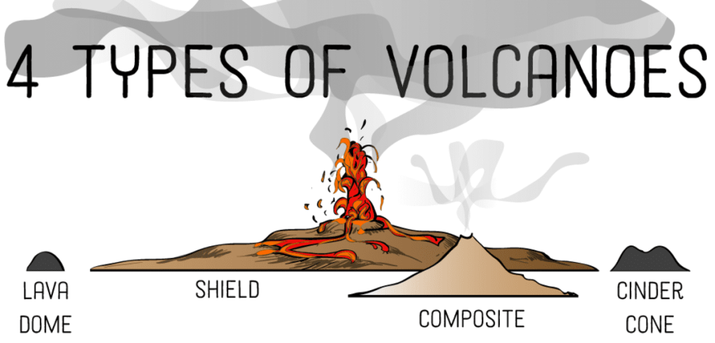
- Cinder cones
- Cinder cones are of low height and are formed of volcanic dust and ashes etc pyroclastic material.
- Falling under the influence of gravity, these particles accumulate around the vent, in a large pile.
- The form of a cinder cone is very distinctive, with steep straight sides and a crater (depression) at the top of the hill. E.g.: Volcano Parícutin, Mexico.
- Composite cones
- A composite cone results when formative eruptions are sometimes effusive and sometimes explosive.
- Composite cones are therefore composed of a combination of lava flow and pyroclastic materials.
- They are also called stratovolcanoes because they are constructed of layers (strata) of pyroclastics and lava.
- They are formed due to deposition of alternate layers lava and fragmental material wherein lava acts as cementing material. E.g.: Mount Fuji in Japan.
c- Shield volcanoes
- When numerous successive basaltic lava flow occur in a given region they can eventually pile up into the shape of a large mountain called a shield volcano.
- E.g.: Mauna Loa, Hawaii
d- Parasitic Cone
- It formed in the vicinity of the main cone and feed on the main cone.
e- Craters
- It is a pit at the top of a volcanic vent.
f- Calderas
- A caldera is a large, basin shaped depression formed at the volcanic mouth.
- It forms when summit material on a volcanic mountain collapses inward after an eruption or other loss of magma. E.G.: Crater Lake, USA.
g- Hot springs
- Ground water, coming in contact with the magma, gets heated beyond 36° C.
- It comes to the surface as hot spring. e.g. Ladakh, Manali, volcanic regions of Iceland, Yellow Stone National Park.
h- Geyser
- It is a special type of hot spring, which ejects steam and superheated water from an underground source through a hole in the ground, intermittently.
- For example, old faithful geyser in the USA.
Q- geophysical characteristics of Circum- Pacific Zone

