Sydney weather: Man forced to use JET SKI to get from one outback town to another due to heavy rain
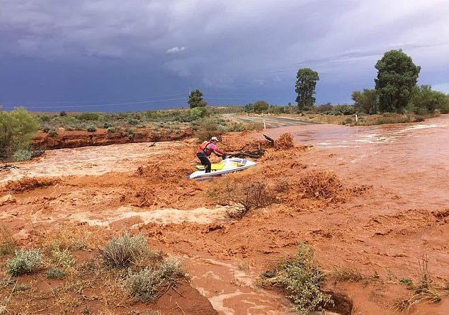
A man has been spotted using a jet ski to travel between two normally parched outback towns as flooding hits large areas of New South Wales.
Video captured on the weekend showed the man using the jet ski in a flooded creek between Broken Hill and Silverton in the state’s far west.
Onlookers watched and cheered as the man rode the jet ski.
Typically, people are advised not to drive in flood waters as it could sweep away your vehicle.
Deadly creatures such as snakes can also be hidden in murky flood waters.
A severe thunderstorm warning has been issued for parts of the NSW mid-north coast and northern tablelands with heavy rainfall expected.
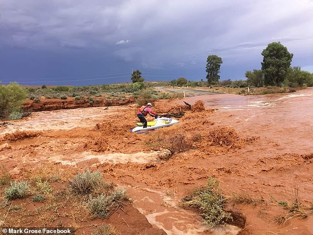
A man is seen jet-skiing from Broken Hill to Silverton in far western NSW after heavy rain hammered the area
Meteorologist Matt Marshall said heavy rainfall leading to flash flooding was expected (Pictured: Gilbert River, between Georgetown and Croydon)
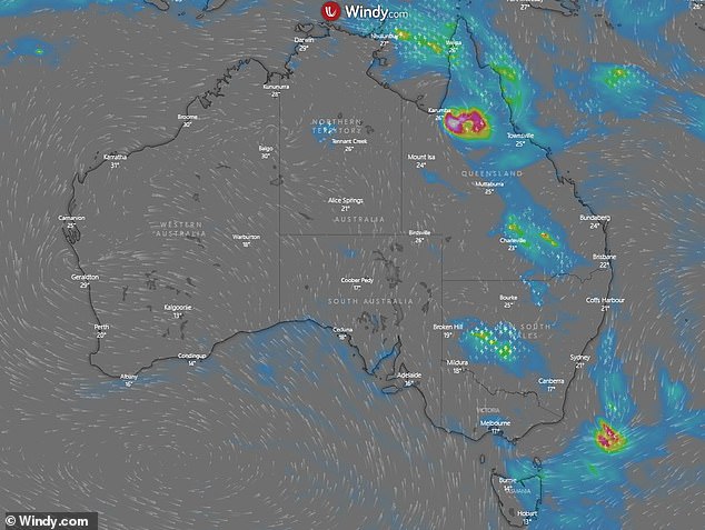
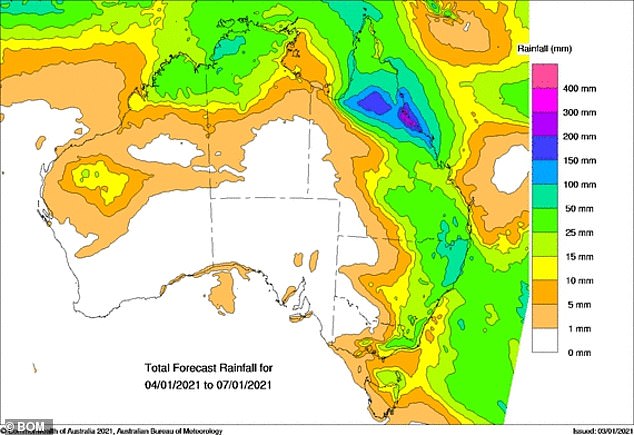
Parts of Australia are in for a drenching as wild weather sweep across the eastern seaboard
Broken Hill, where the footage was captured, is normally a dry area but has been one of the hardest hit by rainfall.
The footage showed a black four wheel drive towing two jet skis into the flood waters.
However, only one man was brave enough to hop on board and go for a ride on one of the jet skis.
His friends clapped, cheered and filmed him as they watched on.
The warning comes after wild weather caused significant damage in the state’s central west on Saturday.
Parkes, in the Central West, received 31mm of rain in just 17 minutes during the Saturday afternoon downpour.
By Sunday morning, the town was drenched with 52mm of rain by the storm that also brought damaging winds and large hailstones.
Part of another roof blew off and residential properties also experienced flooding.
Thunderstorms across much of NSW prompted 45 calls for assistance between 6pm Saturday and 6am Sunday, the State Emergency Service said.
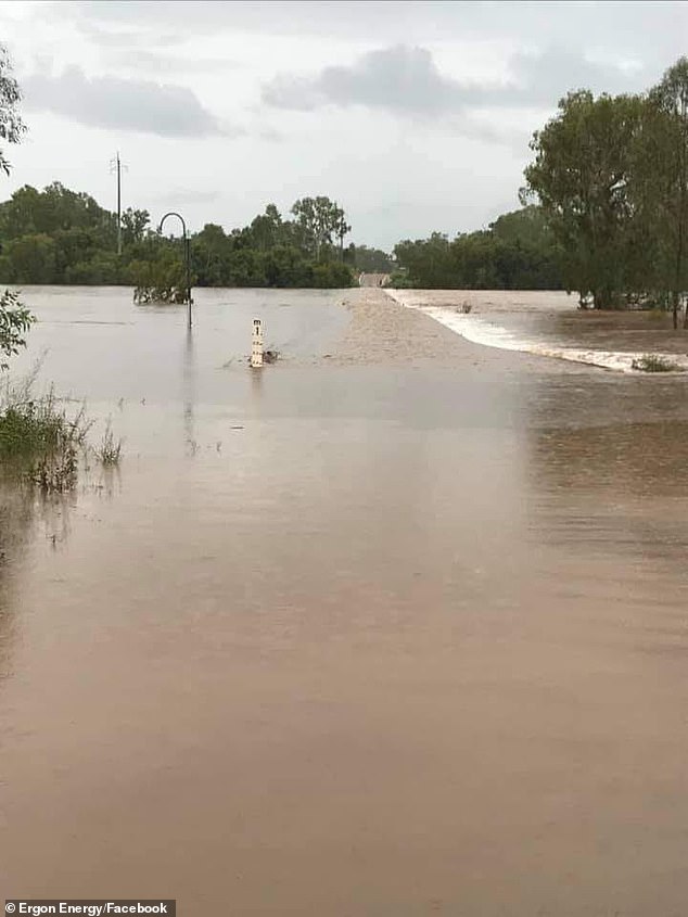
Broken Hill and Parkes have been hardest hit by the extreme weather over the past few days, with Wauchope and Taree on the mid north coast also affected.
Rain and storms will continue in most of NSW with warnings of flash flooding in some areas
The biggest downpour on Saturday was at Okeh to the north, which copped more than 61mm to 9am Saturday.
The SES has responded to 300 incidents state wide since New Year’s Eve, including four flood rescues.
Near Parkes, a person was trapped in a car in flood water.
A driver and passengers were stranded in their vehicle in Tibooburra, in the state’s west, on New Year’s Eve, while at Wauchope, on the mid north coast, two people had to be rescued from rising waters late on Friday.
Persistent, unpredictable bad weather caused dangerous flash flooding around the mid north coast, closing bridges and roads, Ilana Pender-Rose of the SES told AAP on Sunday morning.
A severe thunderstorm warning has also been issued for parts of the mid north coast and northern tablelands with heavy rainfall expected
About 1640 residents remain circled by water and cut off in Taree, Harrington and Camden Haven.
Some are expected to be isolated for weeks, ot
hers for only a few days.
There are flood alerts for the Bellinger, Hastings, Paroo and Camden Haven rivers.
The wet weather has been caused by an inland trough with upper level system support, Shuang Wang of the Bureau of Meteorology said.
Monday is expected to be a ‘big day’ across the most eastern part of the state, potentially affecting Sydney and Canberra, Ms Wang said.
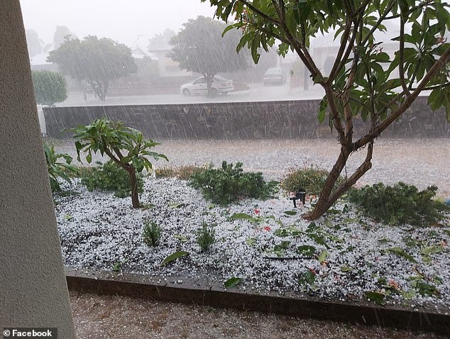
‘Please take it easy, think before you drive anywhere and be aware of the flood risk of wherever you are staying,’ Ilana Pender-Rose of the SES urges all to take care and be ready (Pictured: Resident’s front yard in Broken Hill)

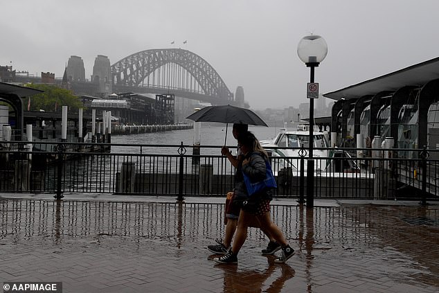
Sydney will be experiencing a wet few days with no signs of it ending for at least a week
‘We’re asking people to get ready because this probably isn’t over,’ Ms Pender-Rose said.
She asked people to be aware of flood risks as they return from holidays around NSW but especially on the mid north coast, where SES volunteers have set up sandbagging stations.
‘Please take it easy, think before you drive anywhere and be aware of the flood risk of wherever you are staying,’ she said.
Sydney is also in for a rainy few days. The forecast has a very high chance of rain until Tuesday, with a good chance of showers beyond that.
Swimmers were warned to avoid Bronte Beach and Narrabeen Lagoon because of pollution caused by rain. Many other swimming sites throughout the city and the Illawarra are also affected.
FIVE DAY WEATHER IN YOUR CITY:
SYDNEY
MONDAY: Min 20 Max 29 Showers, Possible storms
TUESDAY: Min 19 Max 26 Shower or two
WEDNESDAY: Min 19 Max 25 Shower or two
THURSDAY: Min 19 Max 24 Shower or two
FRIDAY: Min 18 Max 24 Shower or two
BRISBANE
MONDAY: Min 23 Max 30 Partly cloudy
TUESDAY: Min 23 Max 32 Partly cloudy
WEDNESDAY: Min 24 Max 30 Showers increasing
THURSDAY: Min 22 Max 26 Shower or two
FRIDAY: Min 21 Max 28 Possible shower
ADELAIDE
MONDAY: Min 16 Max 24 Cloudy
TUESDAY: Min 13 Max 25 Partly cloudy
WEDNESDAY: Min 13 Max 25 Partly cloudy
THURSDAY: Min 13 Max 29 Mostly sunny
FRIDAY: Min 17 Max 33 Mostly sunny
CANBERRA
MONDAY: Min 15 Max 26 Showers, Possible storm
TUESDAY: Min 14 Max 25 Shower or two
WEDNESDAY: Min 13 Max 24 Partly cloudy
THURSDAY: Min 11 Max 23 Cloudy
FRIDAY: Min 10 Max 23 Cloudy
MELBOURNE
MONDAY: Min 17 Max 21 Shower or two
TUESDAY: Min 15 Max 21 Shower or two
WEDNESDAY: Min 14 Max 20 Possible shower
THURSDAY: Min 13 Max 27 Partly cloudy
FRIDAY: Min 15 Max 29 Sunny
PERTH
MONDAY: Min 17 Max 35 Sunny
TUESDAY: Min 19 Max 36 Sunny
WEDNESDAY: Min 22 Max 37 Sunny
THURSDAY: Min 24 Max 37 Mostly sunny
FRIDAY: Min 24 Max 37 Partly cloudy
HOBART
MONDAY: Min 14 Max 22 Shower or two
TUESDAY: Min 13 Max 21 Possible shower
WEDNESDAY: Min 14 Max 20 Possible shower
THURSDAY: Min 10 Max 22 Partly cloudy
FRIDAY: Min 12 Max 24 Mostly sunny
DARWIN
MONDAY: Min 26 Max 34 Possible shower or storm
TUESDAY: Min 26 Max 33 Shower or two, Possible storm
WEDNESDAY: Min 25 Max 33 Showers, Possible storm
THURSDAY: Min 25 Max 33 Shower or two, Possible storm
FRIDAY: Min 25. Max 33. Shower or two, Possible storm
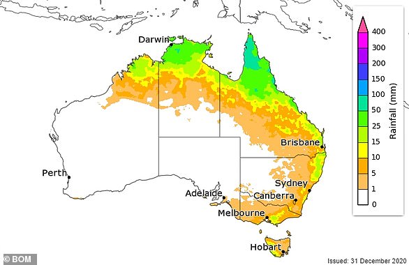
Source: Bureau of Meteorology

Northern and eastern part of Australia expected to be hit with rain over the next seven days